Webquest - Across the U.S.A
INTRODUCTION
A group of foreign exchange students has been invited to spend a semester at your school. The students will tour the United States by car before arriving in your town. Because they won't have time to travel throughout the entire United States, they've decided to focus their tour on only one region of the country. They've asked your class to help them decide which region to explore.
A group of foreign exchange students has been invited to spend a semester at your school. The students will tour the United States by car before arriving in your town. Because they won't have time to travel throughout the entire United States, they've decided to focus their tour on only one region of the country. They've asked your class to help them decide which region to explore.
TASK
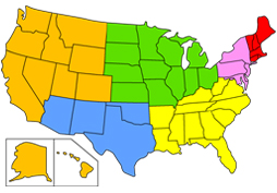
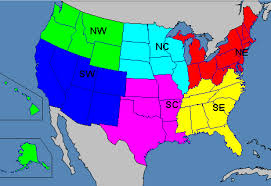
You and your classmates will work in teams to explore six regions of the United States: New England, the Mid Atlantic states, the South, Southwest, Midwest, and West. Each team will investigate one region's landmarks, monuments, and other areas of interest, and then create a brochure describing and illustrating an interesting and informative tour of that region.
You and your classmates will work in teams to explore six regions of the United States: New England, the Mid Atlantic states, the South, Southwest, Midwest, and West. Each team will investigate one region's landmarks, monuments, and other areas of interest, and then create a brochure describing and illustrating an interesting and informative tour of that region.
PROCESS
Step 1: Have each team member choose one of the following roles:
Step 3: Have each team member choose one or more states in that region. Be sure all the states in the region are included.
Step 4: Have each team member use appropriate online resources as well as library resources, if available, to explore his or her states' landmarks, monuments, and other areas of interest.
Step 5: Meet as a group to choose the 10 most interesting places of interest in the region. Try to include at least one place from each state.
Step 6: Find on a U.S. map each of the places selected. Create a regional map showing those places and illustrating the route your tour will take.
Step 7: Assign one or more of the selected locations to each team member. Have team members create a page for each of their assigned locations. Each page should include a picture of the location -- either drawn or downloaded from the Internet -- as well as a brief description of the location's history and significance.
Step 8:Present your brochure to your classmates.
Step 1: Have each team member choose one of the following roles:
- The team leader will conduct team meetings and make final decisions and assignments in the event of disagreements among team members.
- The mapmaker will create a map of the tour.
- The organizer will compile all the elements of the brochure and combine them in the most logical order.
- The tour guide will present the tour to the rest of the class.
Step 3: Have each team member choose one or more states in that region. Be sure all the states in the region are included.
Step 4: Have each team member use appropriate online resources as well as library resources, if available, to explore his or her states' landmarks, monuments, and other areas of interest.
Step 5: Meet as a group to choose the 10 most interesting places of interest in the region. Try to include at least one place from each state.
Step 6: Find on a U.S. map each of the places selected. Create a regional map showing those places and illustrating the route your tour will take.
Step 7: Assign one or more of the selected locations to each team member. Have team members create a page for each of their assigned locations. Each page should include a picture of the location -- either drawn or downloaded from the Internet -- as well as a brief description of the location's history and significance.
Step 8:Present your brochure to your classmates.
RESOURCES
EVALUATION
Your grade will reflect:
CONCLUSION
Use what you've learned about U.S. landmarks to plan your own tour of the United States. Describe the places you would visit and draw a map of your proposed route. How many miles would you travel? How long would your tour take?
Your grade will reflect:
- the accuracy of your research as demonstrated by the information in the brochure. (25 percent)
- the overall quality of the brochure. (20 percent)
- the quality of your group's final presentation. (30 percent)
- your contribution to the group process. (25 percent)
CONCLUSION
Use what you've learned about U.S. landmarks to plan your own tour of the United States. Describe the places you would visit and draw a map of your proposed route. How many miles would you travel? How long would your tour take?
