Crack the Code: Latitude and Longitude
Your Mission
Crack the code to find out where the thieves are taking the loot.
Briefing
Crafty robbers broke into the Royal Geographical Society in London and stole armfuls of priceless maps. Finding them would be hopeless, except that they dropped a scrap of paper with some odd scribbles on it. The scrap paper is pictured below.
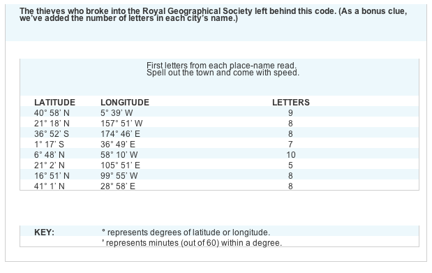
At the top is a rhyme that seems to be an instruction from the thieves' boss:
First letters from each place-name read.
Spell out the town and come with speed.
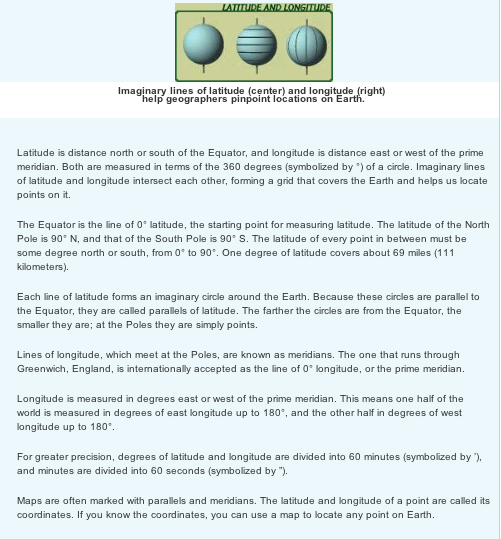
But the note doesn't mention any places! All you see are weird combinations of letters and numbers. Luckily, a sharp-eyed geographer peers over your shoulder and says, "Coordinates. How fascinating!" She refreshes your memory on latitude and longitude , those imaginary lines that help us locate places.
The numbers, you realize, are the coordinates for cities all over the planet. (1) Find those places in an atlas or on a map. (2) As you find each place, write its name next to the coordinates. (3) Circle the first letter of each name. (4) Read the letters from top to bottom, and they should spell the name of a city. Now you know where to nab those cartographic crooks.
(Once you think you've cracked the case, you may want to check your answer .)
F A M I L Y - X F I L E S
Younger Xpeditioners: Find the latitude and longitude of the place where you live. You may need the help from your parents, a teacher, or a librarian.
Older Xpeditioners: Find your birthday coordinates. Use the month for latitude and day for longitude. For example, if your birthday is November 26, your coordinates could be 11°N, 26°E. (You can actually make four sets of coordinates for your birthday, depending on whether you use north or south latitude, or east or west longitude.) Print a world map from the Xpeditions atlas and plot your birthday coordinates. What would it be like to have a party there?
Parents: Depending on how much your children have already learned about latitude and longitude , you may need to brief them a bit. If the concept seems hopelessly complex, you might start with a simple map of a familiar place. Show how the map's grid helps you locate what you're looking for. Then use a globe to help the kids find the Equator and prime meridian.
First letters from each place-name read.
Spell out the town and come with speed.
But the note doesn't mention any places! All you see are weird combinations of letters and numbers. Luckily, a sharp-eyed geographer peers over your shoulder and says, "Coordinates. How fascinating!" She refreshes your memory on latitude and longitude , those imaginary lines that help us locate places.
The numbers, you realize, are the coordinates for cities all over the planet. (1) Find those places in an atlas or on a map. (2) As you find each place, write its name next to the coordinates. (3) Circle the first letter of each name. (4) Read the letters from top to bottom, and they should spell the name of a city. Now you know where to nab those cartographic crooks.
(Once you think you've cracked the case, you may want to check your answer .)
F A M I L Y - X F I L E S
Younger Xpeditioners: Find the latitude and longitude of the place where you live. You may need the help from your parents, a teacher, or a librarian.
Older Xpeditioners: Find your birthday coordinates. Use the month for latitude and day for longitude. For example, if your birthday is November 26, your coordinates could be 11°N, 26°E. (You can actually make four sets of coordinates for your birthday, depending on whether you use north or south latitude, or east or west longitude.) Print a world map from the Xpeditions atlas and plot your birthday coordinates. What would it be like to have a party there?
Parents: Depending on how much your children have already learned about latitude and longitude , you may need to brief them a bit. If the concept seems hopelessly complex, you might start with a simple map of a familiar place. Show how the map's grid helps you locate what you're looking for. Then use a globe to help the kids find the Equator and prime meridian.
